
How to Find Property Lines
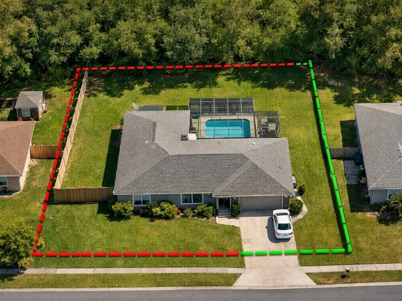
Most homeowners have no real idea where their property ends. You know where your lawn stops. You know where your fence is. Those two things are often not the same, and that gap creates legal headaches that cost real money to fix.
Before you build a fence, pour a driveway, add a pool or start any project near a boundary, you need to know your actual property line. Not what your neighbor said. Not what the app on your phone shows. The only number that counts is the one on a recorded land survey.
Here is every reliable way to find it.
What Is a Property Line?
A property line is the legal boundary that separates your land from neighboring parcels, streets and shared spaces. It’s established by a licensed surveyor, recorded with your local government and does not change over time, regardless of where fences, driveways or landscaping currently sit.
Property lines are set when land is platted or subdivided and recorded with the county. They stay fixed unless a formal legal process changes them. A fence sitting three feet inside your neighbor’s yard for decades does not move the line. The recorded boundary is the boundary, full stop.
That is why guessing, or trusting a fence as your guide, gets people into trouble.
How to Find Property Lines: 6 Methods
1. Check Your Property Deed
Your deed is the first document to pull. The legal description inside it defines your parcel using compass bearings and measured distances. It might read: “beginning at an iron pin on the north line of Oak Street, then north 89 degrees east 150 feet.” That language tells you the exact shape and size of your land.
If you don’t have a physical copy, your county recorder’s office keeps the record. Most counties now offer free online searches. Type in your address or parcel number and the deed comes up in seconds.
One thing to know: the deed describes the boundary in words, but it won’t draw it for you. That’s what the plat map is for.
2. Pull Your Plat Map
When a developer builds a subdivision, they file a plat with the county. That drawing shows every lot, its dimensions and how it connects to neighboring parcels and streets. It stays on file permanently.
Your county assessor’s or recorder’s office keeps these maps, and many offices post them online for free. Look for your lot number and read the measurements along each boundary line. Those numbers tell you how long each side of your property runs. Combined with your deed, this gives you a solid picture of what you own.
3. Search Your County’s GIS Viewer
Most counties run a free online mapping tool called a GIS viewer. Type your address and a parcel boundary appears on an aerial photo. You can see your lot shape, spot whether a neighbor’s fence looks clearly out of place and get a general sense of your boundaries.
Stop there, though. Every county GIS map carries a legal disclaimer: the lines shown are not surveyed boundaries and cannot be used for legal purposes. The data comes from tax records and aerial imagery, not fresh field surveys. Many county GIS parcel databases update only once or twice per year, and some rural counties update even less often. The lines on screen can be off by anywhere from a few feet to more than 10 yards. Treat the GIS viewer as a starting point, not a final answer.
4. Review Your Closing Documents
When you purchased your home, your closing package likely included a survey or plat showing your lot boundaries, corner markers and any recorded easements. Dig through those files. If you can’t find them, call your title company. They keep copies and can usually pull one quickly.
One caution worth knowing: the survey done at closing is sometimes a basic location survey, not a full boundary survey. A location survey may show where your house sits but not place physical markers at every corner. Check which type you received before relying on it for a fence or building permit.
5. Find Your Physical Survey Pins
When a surveyor marks your property corners, they drive a thin iron rod or rebar into the ground at each corner. These are called survey pins or survey monuments. They’re typically half an inch in diameter, flush with the ground or just below the surface, and sometimes capped with a small plastic marker stamped with the surveyor’s license number.
Walk your lot corners with a cheap metal detector. Survey pins sit 12 to 18 inches below or at the surface. Check near sidewalk joints, along fence lines and at driveway edges. A pin cap stamped with a number identifies the surveying firm that set it.
If you locate pins at two or more corners, measure between them and compare to your plat dimensions. Two confirmed pins give you a reliable picture of your boundary.
Do not move a survey pin. In most states, disturbing or removing a survey monument is a criminal offense.
6. Hire a Licensed Land Surveyor
Some situations call for a professional survey and nothing else. If you’re building anything close to a property line, pulling a permit for a fence or pool, buying raw land or dealing with a neighbor dispute, a licensed surveyor is the only answer that holds up legally.
Setback rules require structures to sit a minimum distance from the boundary. Get that wrong by a few inches and you may be forced to tear the structure down. A court, a title company and a building department all require a signed survey from a licensed professional. A GIS printout won’t get you through the door.
According to a 2025 survey cost analysis by The Land Geek, the national average for a residential boundary survey runs between $500 and $1,200. Complicated lots, heavy vegetation and older deed records push the price higher. Even at the top of that range, it’s far cheaper than the average property line lawsuit, which costs $15,000 to $50,000 per party in legal fees.
Are Property Line Apps Accurate?
Apps like LandGlide and Regrid show parcel boundaries from county GIS data on your phone. They’re convenient, but they’re not accurate enough for legal or construction use. LandGlide’s own terms of service state the lines “are not intended to represent actual recently surveyed property lines and are not recommended to use for legal purposes.”
Smartphone GPS accuracy sits within 16 feet under ideal conditions. Near buildings and tree canopy, it gets worse. Users have reported app boundaries being off by 10 yards or more.
These apps work fine for a rough first look. Never base a building decision on them.
When You Need Each Method
For quick visual planning, the GIS viewer and plat map are enough. They’re free and take minutes. For a fence layout or rough landscaping project, combine your deed, plat and any pins you find on the ground. That combination gets you close.
Once you’re pulling permits, building anything permanent or buying land, stop using free tools. A boundary survey is the only result that holds up in those situations. And if a dispute with a neighbor is already in play, free methods won’t help you. A court, a title company and a building department all want the same thing: a signed survey from a licensed professional. Nothing else counts.
Frequently Asked Questions
How do I find my property lines for free?
Start with your county recorder’s office to pull your deed and plat map. Then search your county’s GIS parcel viewer online. Both are free. Walk your lot with a metal detector to look for existing survey pins. Those three steps give you a solid working estimate at no cost.
How accurate are property line apps?
Not accurate enough for construction or legal use. Apps like LandGlide draw from county GIS data, which can be off by 10 yards or more. LandGlide states in its own terms that its lines are not legally valid. Use them only for general orientation.
Can I move a survey pin if it’s in my way?
No. Moving, removing or disturbing a survey monument is a criminal offense in most states. If you find a pin that seems wrong, hire a licensed surveyor to evaluate it.
How long does a boundary survey take?
Most residential boundary surveys take one to three days from fieldwork to final document delivery, though timelines vary by surveyor workload and record complexity.