
Survey Mapping Guide for Conflicting Property Lines
When two survey maps show different property lines, the conflict is usually caused by missing or moved boundary monuments, different starting reference points, or surveys done at different precision levels. Don’t move any markers, compare both surveys side by side, call both surveyors, and get a third independent survey if the disagreement holds.
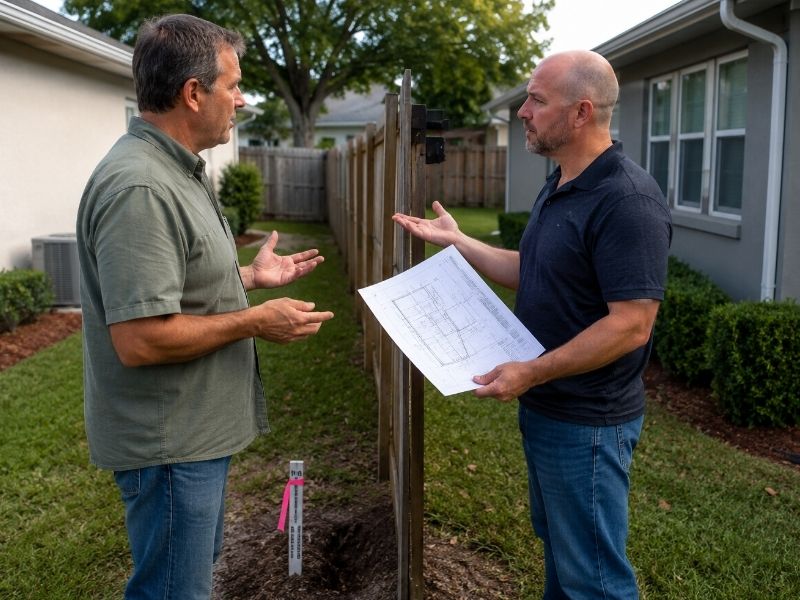
You paid for a land survey. Your neighbor paid for one too. Now you’re both looking at two different maps that say the property line is in two different places. Situations like this often lead homeowners to look for survey mapping for property disputes when property lines become unclear.
So who’s right?
This situation is more common than most homeowners expect. Before you call a lawyer or start an argument over the fence, take a breath. There’s a clear process for sorting this out, and it’s calmer than you’d think.
Why Two Surveys Can Legally Show Different Property Lines
Two licensed surveyors can legally produce different property line results when they use different boundary monuments as starting points, when original monuments are missing or disturbed, or when one survey is a lower-precision document like a mortgage location sketch rather than a full boundary survey.
Two licensed surveyors looking at the same property can arrive at different conclusions without either one being dishonest or incompetent. The reason almost always comes down to physical conditions on the ground.
The Role of Boundary Monuments
Surveys start from fixed physical markers called monuments. These are iron pins, concrete posts, or other objects set in the ground to mark a corner. Monuments move more often than people realize:
- Road and utility crews dig them up during construction work
- Landscapers accidentally pull them out
- Storms and flooding displace them
- In older neighborhoods, some simply rust away and disappear
When a surveyor can’t find the original monument, they have to work backward from surrounding markers that may be much farther from your property. The farther back they start, the more room there is for small measurement differences to grow. A two-inch gap at one corner can turn into six or eight inches by the time the line runs across a 400-foot lot.
Survey Type Matters Too
Not all surveys are created equal. A mortgage location survey, the kind ordered during a home purchase, is less precise than a full boundary survey with iron pins physically set in the ground. If one of you has a basic location sketch and the other has a full boundary survey, those two documents were never meant to produce the same result. They’re different products entirely.
So yes, two honest, licensed surveyors can produce maps that don’t quite match. It’s math and field conditions, not fraud.
What to Do When Your Survey Maps Conflict: Step-by-Step
Homeowners should follow five steps when survey maps conflict: don’t disturb any markers, compare both surveys for date and type differences, contact both surveyors directly, understand which survey carries legal weight based on physical evidence, and commission a third independent survey if the disagreement remains unresolved.
Step 1: Don’t Touch Anything
Before anything else, don’t touch the stakes, markers, or pins from either survey. Don’t build, fence, or grade. Moving a survey marker is illegal in most states, and disturbing the physical evidence before the conflict is resolved makes everything harder, both practically and legally.
If your neighbor has already started building based on their survey, a calm conversation is the right first move. Let them know you have a conflicting result and ask them to pause until you both get clarity. Most people respond reasonably when you’re not accusatory about it.
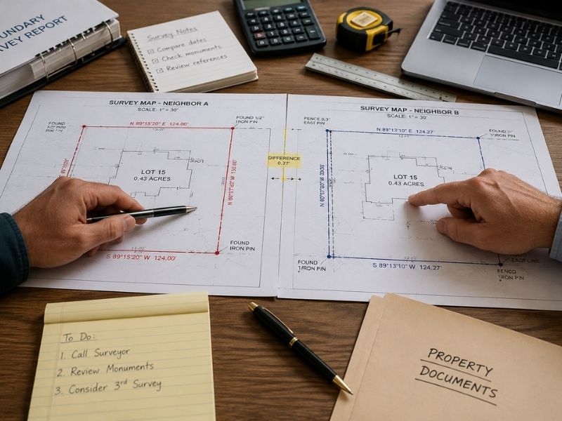
Step 2: Compare Both Surveys Side by Side
Pull out both survey maps and check three specific things:
- The date. An older survey might reference a monument that no longer exists or use a different starting reference point. A newer survey isn’t automatically more accurate, but it may better reflect current ground conditions.
- The starting point. Look at what each surveyor used as their reference. Different monuments or different benchmarks will produce different results, and that alone often explains the gap.
- The survey type. A mortgage location survey is a lower-precision document. A full boundary survey with corners physically set and certified is a much more authoritative result. Comparing these two as equals is a common mistake.
Step 3: Call Both Surveyors Directly
This step surprises most homeowners, but it works. Call both surveyors, explain what you found, and ask each of them to review the other’s work. Ask where they think the difference comes from.
A licensed surveyor can look at a competing survey and explain exactly what caused the discrepancy. Maybe they used different monuments. Maybe one found a pin that had shifted. Surveyors resolve these conflicts directly with each other every day, often without anyone spending more money.
If they can’t resolve it by phone, ask your surveyor to go back to the field and specifically investigate the discrepancy. A field re-check targeted at the conflict point usually costs far less than a full re-survey.
Step 4: Understand Which Survey Carries More Legal Weight
When two surveys conflict, resolution depends on which one has more reliable physical evidence, not which is newer or more expensive.
Courts and surveyors consistently apply a clear hierarchy:
- Found original monuments carry the most weight
- Measured positions from reliable nearby monuments come next
- Calculated positions without physical evidence carry the least
If one surveyor found an original iron pin from the subdivision plat and the other only found a disturbed or missing monument, the survey grounded in physical evidence will prevail.
Long-term use patterns also factor in. A judge would consider the recorded plat, deed descriptions, physical monuments found in the field, and any fence or marker both neighbors treated as the line for years. Many states recognize a doctrine called boundary by acquiescence, where a boundary both neighbors accepted for a sustained period can become the legal line regardless of what a new survey shows. Check with a local real estate attorney to understand how your state handles this.
Step 5: Commission a Third Independent Survey
If both surveyors stand by their results and can’t explain the difference, a third independent survey is the cleanest path forward. Both parties agreeing to hire the same surveyor and split the cost removes the adversarial element entirely.
Ask the third surveyor to specifically review both prior surveys, address the conflict in writing, and state clearly which result they believe is supported by the evidence.
When You Need a Real Estate Attorney
Get a real estate attorney involved when a neighbor has already built on disputed land, when the difference is several feet rather than inches, or when your neighbor refuses to participate in a third survey. Waiting too long to act can reduce your legal options under most states’ property dispute statutes.
Most conflicting survey situations get resolved between property owners and surveyors without going to court. But a few circumstances make early legal involvement the smarter call:
- Your neighbor has already built a structure on the disputed area. Most states have a statute of limitations on property disputes ranging from five to ten years. Acting early protects your rights.
- The discrepancy is measured in feet, not inches. A large gap rarely resolves itself without formal intervention.
- Your neighbor refuses to participate in a shared third survey. An attorney can pursue a quiet title action to have a court officially establish the boundary.
A Note on Waterfront and Coastal Properties
Waterfront properties face a higher rate of survey conflicts because mean high water lines and coastal setback boundaries shift over time due to storms, erosion, and tidal changes. Any survey on a waterfront property should specifically address current water line locations, not just fixed boundary corners.
If your property sits near a canal, river, or the coast, conflicting surveys are even more frequent. Waterfront surveys reference moving lines like mean high water, which can shift meaningfully after storms or years of erosion. An older survey may not show where those lines actually sit today.
Before relying on any waterfront survey for construction, fencing, or a property transaction, confirm it addresses current water line locations and any applicable coastal setback restrictions. Outdated surveys on waterfront lots are one of the most common sources of expensive property disputes.
What To Do Right Now
If you’ve got two conflicting survey maps, start with the calm approach. Call your surveyor first. Ask them to review the competing map and give you a written explanation of the difference. Most of the time, the answer is in the field: a moved pin, a missing monument, or a different starting reference point.
A local survey mapping professional who knows your area’s ground conditions, local records, and state boundary rules can resolve this faster than you’d expect. Getting accurate information now costs far less than letting a small disagreement become a legal fight over a fence line.
Frequently Asked Questions
Can two surveys of the same property show different results?
Yes. Two licensed surveyors can produce different results when they use different starting monuments, when original markers are missing or disturbed, or when one survey is a lower-precision document than the other. The difference is usually explainable and resolvable.
Which survey is legally correct when two surveys conflict?
The survey with more reliable physical evidence generally prevails. Courts give priority to surveys built on original found monuments over those relying on calculated or estimated positions. A local real estate attorney can advise on how your state’s law handles specific conflicts.
Do I need a lawyer if my neighbor’s survey is different from mine?
Not immediately. Start by comparing both surveys and contacting the surveyors directly. If the difference is large, a neighbor has already built on the disputed area, or direct resolution fails, consulting a real estate attorney early protects your legal options.
What is the boundary by acquiescence?
Boundary by acquiescence is a legal doctrine recognized in many states. It holds that when two neighboring property owners treat a specific line as their shared boundary for a sustained period, that line can become legally binding even if a new survey shows a different result.
How much does a third independent survey cost?
Survey costs vary by property size, location, and complexity. A targeted re-survey focused on a specific disputed boundary costs less than a full property survey. Getting written quotes from two or three licensed surveyors in your area is the best way to get an accurate estimate.