This site is intended to provide you with information on Land Surveying in the Fort Myers, FL and Lee County area of Florida. If you’re looking for a Fort Myers Land Surveyor, you’ve come to the right place. If you’d rather talk to someone about your land surveying needs, please call our local number at (239) 800-0481 today. For more information, please continue to read.
Land Surveyors are professionals who make precise measurements to determine the size and boundaries of a piece of real estate. While this is a simplistic definition, boundary surveying is one of the most common types of surveying related to home and land owners. If you fall into the following categories, please click on the appropriate link for more information on that subject:
Fort Myers Land Surveying services:
I need to know where my property corners or property lines are. (Boundary Survey)
I have a loan closing or re-finance coming up on my home in a subdivision. (Lot Survey)
I need a map of my property with contour lines to show elevation differences for my architect or engineer. (Topo Survey)
I’ve just been told I’m in a flood zone or I’ve been told I need an elevation certificate in order to obtain flood insurance or prove I don’t need it. (Flood Survey)
I’m purchasing a lot/house in a recorded subdivision. (Lot Survey – See Boundary Survey if you’re not in a subdivision.)
I’m purchasing a larger tract of land, acreage, that hasn’t been subdivided in the past. (Boundary Survey)
Contact Fort Myers Land Surveying services TODAY at (239) 800-0481.
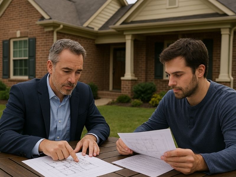
A lot of property owners get asked for an elevation certificate and have no idea what it is, who prepares it or why it exists. That confusion costs money. The wrong person filling it out, or skipping it entirely, leads to higher flood insurance premiums, failed permit applications and lender rejections at closing.
This article explains exactly who is legally allowed to prepare an elevation certificate, what the process looks like and what the finished document actually does.
What an Elevation Certificate Is
An elevation certificate is an official FEMA form. It documents the elevation of a building relative to the Base Flood Elevation (BFE) for that property. The BFE is the height floodwater is expected to reach during a major flood event in that area.
The certificate records specific elevation measurements for the building, the lowest floor, the garage and any attached machinery. It also identifies the flood zone the property sits in and provides data that insurance companies use to calculate flood insurance premiums.
Without accurate elevation data, insurers have to make assumptions. Those assumptions almost always result in higher premiums.
Who Can Legally Fill Out an Elevation Certificate
Only three types of professionals are authorized to complete and certify an elevation certificate:
A licensed land surveyor
A licensed engineer
A licensed architect
All three must be licensed in the state where the property is located. The professional who signs the certificate takes legal responsibility for the accuracy of the measurements recorded on it.
In practice, licensed land surveyors handle the vast majority of elevation certificates. That’s because the work requires precise field measurements and knowledge of local flood map data, which falls squarely within a surveyor’s scope of work. Engineers and architects can certify them for projects they’re directly involved in, but they rarely do so for standalone certificate requests.
A property owner cannot fill out their own elevation certificate. A contractor cannot fill one out either. If someone other than a licensed professional signs it, it’s not valid and won’t be accepted by an insurance company, a lender or a permit office.
How the Process Works
Step 1: Hire a Licensed Land Surveyor
The first step is finding a licensed surveyor in your area who has experience with flood zone properties and elevation certificates. Confirm their license is active in your state before hiring.
Provide the surveyor with your property address, the legal description and any prior flood-related documents you have. If your property has been through a FEMA map amendment process before, share those records too.
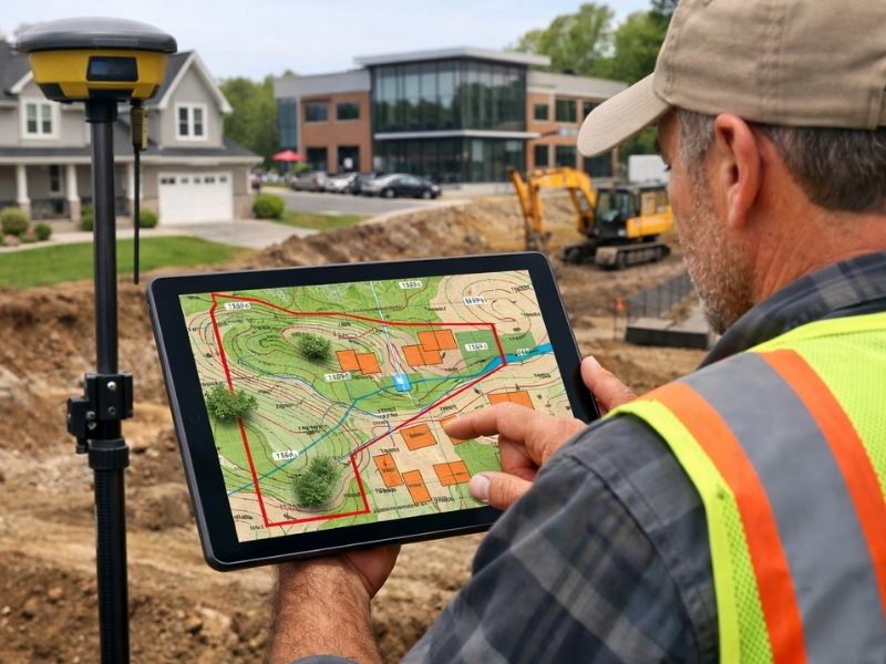
Step 2: The Surveyor Visits the Site
The surveyor visits the property and takes precise elevation measurements. They measure the elevation of the lowest floor of the structure, including the basement if one exists. They also measure the bottom of the lowest horizontal structural member for certain building types, the ground elevation around the building and the elevation of any attached garage or machinery that could be affected by flooding.
The measurements are taken using survey-grade equipment and referenced to a vertical datum, which is a standardized system for measuring elevation above sea level. FEMA currently requires all elevation certificates to use the NAVD 88 datum.
Step 3: The Surveyor Completes the FEMA Form
After field work, the surveyor fills out the official FEMA Elevation Certificate form. The form has several sections covering building information, flood zone data and the elevation measurements collected on site.
The surveyor also attaches a diagram showing which building type applies to the property. FEMA uses different measurement points depending on the structure, so getting the building diagram right affects every elevation value on the form.
Step 4: The Certificate Gets Signed and Sealed
The surveyor signs the certificate and applies their professional seal. That seal makes it official. An unsigned or unsealed certificate is not valid and will be rejected.
The finished certificate is typically delivered as a PDF. Keep the original. You may need it for insurance renewals, property sales, permit applications and any future FEMA map amendment requests.
What Happens After the Certificate Is Issued
Insurance Rating
The elevation certificate goes to your flood insurance provider. The insurer compares your building’s lowest floor elevation to the BFE for your flood zone. If your building sits above the BFE, your premium goes down. If it sits below, the premium goes up.
The difference in premium between a building one foot below the BFE and one foot above it can be several thousand dollars per year. That’s why getting accurate measurements matters. A certificate based on bad data produces a rating that doesn’t reflect the actual risk.
Lender Requirements
Many lenders require an elevation certificate before approving a mortgage on a property in a designated flood zone. They use it to confirm flood insurance is in place and correctly rated.
If your lender asks for one and you don’t have it, the loan doesn’t close until you get it. That’s a timeline problem in most transactions.
Permit Applications
Some local permit offices require an elevation certificate as part of the application for new construction or substantial improvements in flood zones. The certificate confirms the building is being placed at the correct elevation relative to the BFE before permits are issued.
Common Mistakes That Cause Problems
Using an Outdated Certificate
FEMA updates flood maps periodically. If a map revision has changed your property’s flood zone since the certificate was issued, the old certificate may no longer reflect current conditions. An insurer or lender may require a new one.
Wrong Building Diagram Selection
The FEMA form includes diagrams for different building types. Selecting the wrong one changes which elevation point gets measured and reported. An error here affects the entire certificate and can lead to incorrect insurance ratings.
Hiring Someone Without the Right License
This happens more than it should. A contractor or inspector offers to “handle” the elevation certificate as part of a larger job. Unless they hold an active professional land surveyor, engineer or architect license in your state, they can’t legally certify it. Any certificate they produce won’t be accepted.
Frequently Asked Questions
Who is authorized to complete an elevation certificate?
Only a licensed land surveyor, licensed engineer or licensed architect can complete and certify an elevation certificate. The professional must hold an active license in the state where the property is located. Property owners and contractors are not authorized to complete one.
How long does it take to get an elevation certificate?
Most elevation certificates take five to ten business days from the site visit to delivery of the finished document. Turnaround time depends on the surveyor’s current workload and how complex the property is. Rush services may be available for an additional fee.
Do elevation certificates expire?
FEMA elevation certificates don’t have a set expiration date, but they can become outdated. If FEMA revises the flood map for your area, your certificate may no longer reflect the current flood zone classification. Lenders and insurers may require an updated certificate if the map has changed since yours was issued.
Can one elevation certificate be used for multiple purposes?
Yes. A single certificate can be used for flood insurance rating, lender requirements and permit applications at the same time. Keep copies and share them with each party that needs one. You don’t need a separate certificate for each use.
What if the elevation certificate shows my building is below the Base Flood Elevation?
It means your flood insurance premium will be higher than if the building were above the BFE. In some cases, it may also affect financing and resale. Options include applying for a FEMA Letter of Map Amendment if you believe the flood zone designation is incorrect, or making physical improvements to the property such as elevating the structure to bring it above the BFE.
Skipping a construction surveyor feels like a way to save time and cut costs. It’s not. What it actually does is push the cost further down the timeline, where fixing mistakes is far more expensive. Developers who skip this step don’t avoid problems. They just find out about them later, when the damage is already done.
This article covers what goes wrong, how bad it gets and what it costs when a construction surveyor isn’t part of the project from the start.
What a Construction Surveyor Controls on a Project
Before getting into what goes wrong, it helps to understand what a construction surveyor actually does.
A construction surveyor sets the physical reference points that crews work from. They mark where buildings sit on the lot, where utilities go underground and where grading targets need to hit. Every crew on the site works from those marks.
Without that baseline, crews work from plans alone. Plans drawn in an office don’t account for what’s actually on the ground. That gap is where mistakes happen.
What Goes Wrong Without a Construction Surveyor
Structures Built in the Wrong Location
This is the most expensive mistake a developer can make. A building placed even a few feet outside the approved area can trigger a stop-work order, a forced demolition or a variance process with the local permit office.
Setback violations are the most common version of this problem. Every parcel has minimum distances between structures and property lines. Those distances come from zoning rules and recorded easements. A crew without survey control may estimate those setbacks from a plan drawing. Estimates are not measurements. The difference can be the difference between getting your occupancy permit and getting a tear-down order.
Grading and Drainage Failures
Earthwork without survey control produces sites that don’t drain correctly. A grading crew working without elevation targets is guessing at final grades. Some areas end up too low. Others are too high. Water pools where it shouldn’t.
Drainage failures show up after the first heavy rain. By then, pavement is poured and landscaping is in. Fixing the problem means tearing up finished work. In flat areas with heavy rainfall, a grading error of just a few inches can cause standing water that violates permit conditions.
Utility Conflicts and Damaged Lines
Underground utilities need to go exactly where the plans say. A water line installed two feet off its designed location may conflict with a storm drain or a foundation footing. Finding that conflict after excavation means stopping work and redesigning the installation.
In some cases, crews dig into existing utility lines because nobody verified the layout before excavation started. Utility strikes during construction are dangerous and expensive. They’re also almost always avoidable with proper survey control.
Permit Rejections and Inspection Failures
Most permit offices require survey documents at specific phases of construction. Foundation surveys, setback checks and as-built drawings are commonly required before inspections pass.
When a construction surveyor isn’t part of the project from the start, this documentation doesn’t exist. Developers scramble to get a surveyor on site after the fact, only to find that what was built doesn’t match the approved plans. The inspection fails. The permit process restarts. The closing date moves.
That sequence is entirely avoidable.
The Real Cost of Skipping Survey Control
Rework Costs More Than Prevention
Moving a poured foundation costs tens of thousands of dollars. Regrading a finished site costs more than grading it correctly the first time. Relocating underground utilities after they’re buried means digging up finished work and starting over.
Construction surveyors typically cost a small fraction of a project’s total budget. The rework costs that follow a missed survey mark can run into six figures on a mid-size commercial project.
Schedule Delays Add Up Fast
Every day a project sits idle costs money. Subcontractors move to other jobs. Material deliveries get rescheduled. Financing timelines get stressed.
A stop-work order because a structure is outside its approved area can sit for weeks while engineers and permit officers sort out a fix. Some projects never fully recover their schedule after a major setback like that.
Legal Problems From Neighboring Properties
A building that crosses a property line creates an encroachment. Encroachments trigger disputes with neighboring property owners, create title insurance problems and can block a future sale.
A developer who builds across a property line without survey control has limited options when the problem surfaces. Moving the structure is expensive. Litigation is expensive. Neither outcome is good.
When a Construction Surveyor Should Be on Site
A construction surveyor should be involved at multiple phases, not just at the start:
Before grading begins, to set elevation control and site benchmarks
Before foundation work, to verify building placement and setback compliance
During utility installation, to confirm underground lines are in the correct locations
After major phases are complete, to check that work matches the approved design
At project closeout, to produce the as-built documents permit offices require
Treating survey control as a one-time event misses most of the value. Construction sites change constantly. Stakes get knocked over by equipment. Grade targets shift as earthwork moves forward. A construction surveyor who returns at key phases catches those changes before they become permanent.
Frequently Asked Questions
What does a construction surveyor do on a build site?
A construction surveyor sets physical reference points that crews use to place buildings, utilities and grading correctly on a site. They verify that structures are within approved setbacks, that elevations match design targets and that underground utilities are in their correct locations.
How much does a construction surveyor cost?
Costs vary by project size and scope. On most commercial projects, construction surveying runs between 0.5 and 1.5 percent of total construction costs. Either way, the cost is a small fraction of what fixing a placement error costs after the fact.
Can a contractor handle layout without a construction surveyor?
A contractor can place stakes and take measurements, but that work doesn’t carry the legal certification a licensed surveyor provides. Permit offices require certified survey documents at key inspection points. Work done without a licensed surveyor may not satisfy those requirements, which means the project can’t pass inspection.
What happens if a building is placed in the wrong location?
The outcome depends on how far off it is and what it violates. Minor setback issues may be resolved through a variance application. Structures that encroach on neighboring property or sit within an easement area may need to be physically corrected or removed. Both outcomes are expensive and avoidable with survey control from the start.
Is a construction surveyor required by law?
Requirements vary by location and project type. Most permit offices require certified survey documents at specific phases, including foundation placement and project closeout. Even where it’s not legally required at every phase, skipping it leads to failed inspections, permit rejections and rework that cost far more than the survey would have.
Most business buyers spend weeks reviewing financials and talking to brokers. Then they skip the one step that tells them what they’re actually buying. Hiring a commercial property surveyor before closing shows buyers if the property matches what’s on paper. Skip it and you inherit whatever problems were already there.
This article covers what a commercial property surveyor finds, why it matters for business purchases and what happens when it gets ignored.
What a Commercial Property Surveyor Actually Does
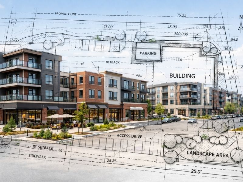
A commercial property surveyor formally measures and documents a property. They visit the site, review recorded documents and produce a drawing. That drawing shows the legal boundary, existing structures, easements, encroachments and flood zone data.
This is not the same as a property inspection. An inspector looks at the building’s condition. A commercial property surveyor looks at the land itself.
A building can pass inspection and still have a boundary problem that blocks financing. Those are two completely different issues.
Why Business Buyers Face Higher Risk Than Homeowners
A homeowner buying a house on a small lot carries relatively low survey risk. The boundaries are usually well-established and the work is straightforward.
Business buyers face a different situation.
Commercial parcels are often larger and more complex. They may have shared access agreements, utility easements or irregular lot shapes. Some were assembled from multiple parcels over time. The legal descriptions don’t always line up cleanly when that happens.
A business buyer purchasing land for a retail center, a warehouse or a medical office is making a decision that affects operations for years. Getting the property wrong at the start is an expensive problem to fix.
What a Commercial Property Surveyor Finds Before You Close
Easements That Limit Your Plans
An easement gives another party the right to use part of your property. Utility easements, drainage easements and access easements all appear on the survey. They get plotted against the property boundary so you can see exactly where they run.
Some easements are minor. Others cut directly through a planned building area or parking lot. Finding that before purchase gives you options. Finding it after the site plan is drawn costs redesign time and money.
Encroachments You Didn’t Know About
An encroachment is anything that crosses a property boundary without legal right. A neighboring building wall, a shared driveway or a fence in the wrong spot.
These are common on older commercial properties. They’re also a serious financing problem. Most lenders won’t fund a deal with an unresolved encroachment. Title companies won’t insure around one without specific negotiations. Finding it before closing puts the problem on the seller. Found after closing, it’s yours.
Boundary Problems in Old Deeds
Older deed descriptions were sometimes written using reference points that no longer exist. A stake, a tree or a corner marker that disappeared decades ago. When a commercial property surveyor goes to locate the boundary, the legal description and the physical conditions on the ground sometimes don’t match.
This happens more often than buyers expect, especially with commercial land that hasn’t changed hands in a long time. A licensed surveyor finds those conflicts before they become your legal problem.
Flood Zone Classification
A commercial survey includes flood zone data for the property. That tells you whether any part of the site falls within a FEMA high-risk flood zone and what insurance and building requirements apply.
For business buyers, this affects construction costs and insurance premiums. It also affects what can legally be built on the site. Getting this information early changes the financial picture for the project.
When Business Buyers Get This Wrong
The most common mistake is treating the commercial property surveyor as a last-minute formality. Buyers order the survey at the end of due diligence, rush the process and then don’t have time to act on what comes back.
A survey that returns problems two days before closing puts you in a bad spot. You’re either closing on a property with known issues or delaying a closing with hard deadlines.
Order the survey the same day you sign the purchase agreement. A standard commercial ALTA survey takes two to four weeks. Complex properties take longer. Ordering early means results come back during due diligence, when you still have time to negotiate or walk away.
How This Affects Financing
Most commercial lenders require an ALTA/NSPS survey before releasing funds. This is a loan condition, not a suggestion.
The ALTA/NSPS standard is set by the American Land Title Association and the National Society of Professional Surveyors. It defines what the survey must show and how it must be certified. A survey that doesn’t meet that standard gets rejected and has to be redone.
Some buyers order a basic boundary survey and find out at closing that it doesn’t satisfy the lender. That mistake adds weeks to the timeline and costs the price of a second survey.
What to Ask Before Hiring a Commercial Property Surveyor
Before signing anything, confirm the following:
They hold an active license in the state where the property is located
They have recent experience with commercial ALTA surveys, not just residential work
The quote covers title research, field work and the final certified drawing
They can deliver within your due diligence window
They carry current errors and omissions insurance
Get that in writing. A verbal commitment from an overbooked surveyor is not a schedule.
Frequently Asked Questions
Do business buyers always need a commercial property surveyor?
Any buyer using a lender to finance a commercial purchase will almost certainly need an ALTA/NSPS survey completed by a licensed commercial property surveyor. Cash buyers have more flexibility, but skipping this step carries real risk. Boundary problems and easements don’t disappear because no one documented them.
How is a commercial property surveyor different from a property inspector?
A property inspector looks at the building: structure, mechanical systems and code compliance. A commercial property surveyor looks at the land: boundaries, easements, encroachments and flood zone status. Both are needed. They answer completely different questions.
What is an ALTA/NSPS survey and why do lenders require it?
An ALTA/NSPS survey follows national standards set by the American Land Title Association and the National Society of Professional Surveyors. It covers more than a standard boundary survey and produces a certified drawing that lenders and title companies accept. Most institutional lenders require it before funding a commercial deal.
Can a commercial property surveyor’s findings change the purchase price?
Yes. If the survey finds an encroachment, a conflicting easement or an undisclosed flood zone, those become negotiating points. A seller who knew about a problem has exposure. A buyer who finds it before closing has leverage. Found after closing, there’s nothing left to negotiate.
How long does a commercial property survey take?
A standard ALTA/NSPS survey takes two to four weeks from start to delivery. Properties with large acreage, complicated title histories or multiple easements can take six weeks or more. Order it the day you sign the purchase agreement, not the week before closing.

 Land Surveyors are professionals who make precise measurements to determine the size and boundaries of a piece of real estate. While this is a simplistic definition, boundary surveying is one of the most common types of surveying related to home and land owners. If you fall into the following categories, please click on the appropriate link for more information on that subject: