
Why Your Pool Permit Needs a Topographic Survey
You finally said yes to the pool. You got the quotes, picked the design, and told your contractor to move forward. Then, out of nowhere, they mention a topographic survey and suddenly your project is on hold.
Sound familiar?
You are not alone. This happens to homeowners all the time. And the most frustrating part is that nobody explains why. Your contractor mentions it like you already know what it means. The building department asks for it like it is obvious. Meanwhile, you are left searching online late at night trying to figure out what went wrong.
The good news is that there is a real reason behind it and once you understand it, the entire process makes a lot more sense.
Many pool permits require a topographic survey because pools, patios, decks, and pool cages add impervious surface that changes drainage patterns on a property. Lee County uses topographic survey data to confirm that stormwater runoff will not flood neighboring lots or create drainage problems before approving a permit.
What Is a Topographic Survey?
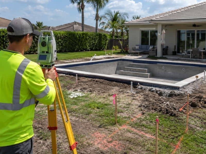
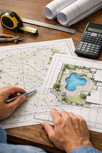
A topographic survey, often called a topo survey, is a detailed map that shows the shape and elevation of your property. It measures slopes, low spots, drainage flow, and changes in ground elevation across the lot.
Unlike a boundary survey, which only identifies property lines, a topographic survey explains how the land itself behaves during heavy rain and flooding conditions.
What a Topographic Survey Measures
A topo survey records important site details such as:
- Elevation changes across the property
- Drainage patterns and water flow
- Existing structures and improvements
- Retaining walls, driveways, and patios
- Trees, fences, and utility features
- Low areas where water may collect
Surveyors use specialized equipment to gather accurate elevation data that engineers and permitting departments rely on during project review.
Why Elevation Matters
In many parts of the country, a slight slope may not seem important. In Fort Myers, it matters a lot.
Southwest Florida sits only a few feet above sea level in many areas. Even a small elevation change can affect where stormwater flows during heavy rain. Fort Myers also receives roughly 54 inches of rainfall each year, which is significantly higher than the national average.
After Hurricanes Ian and Milton caused major flooding across Southwest Florida, local building departments became even more focused on drainage and flood prevention. Lee County now reviews residential projects more carefully to make sure new construction does not create runoff problems for nearby properties.
Why Does a Pool Permit Require a Topographic Survey?
A pool permit may require a topographic survey because new pools, patios, decks, and cages increase impervious surface on a property. Lee County uses topo survey data to review drainage flow, elevation changes, and stormwater impact before approving residential pool construction permits.
Pools Change Drainage Patterns
Here is the part most homeowners never hear until their permit application gets delayed.
When you build a pool, you are not just installing water in the ground. You are also adding hard surfaces like:
- Concrete decking
- Pavers
- Pool cages
- Patios
- Equipment pads
These surfaces do not absorb rainwater naturally. Instead, they redirect stormwater somewhere else.
That runoff may flow toward:
- A neighboring property
- The street
- A drainage swale
- A canal
- Another low area nearby
Without proper grading and drainage planning, even a residential pool project can create flooding problems during Florida storms.
Lee County Impervious Surface Rules
Lee County and nearby municipalities closely monitor impervious surface additions during permitting.
If your project adds a significant amount of hard surface area, the county may require:
- A drainage review
- Engineered grading plans
- Stormwater calculations
- A topographic survey
The goal is not to slow down construction. The county simply needs proof that your new pool will not redirect water into neighboring yards or violate local drainage regulations.
Why Engineers Need Elevation Data
Before an engineer can design a drainage solution, they need accurate information about how the property currently drains.
That is where the topographic survey becomes essential.
The topo survey gives engineers detailed elevation data that helps them determine:
- Where water currently flows
- Whether grading adjustments are needed
- If additional drainage systems are required
- Whether the pool placement creates runoff risks
Without this information, the permit reviewer cannot confirm that the project complies with local drainage requirements.
Why Homeowners Usually Find Out Too Late
Many homeowners only learn they need a topographic survey after permit review begins. Contractors often focus on construction pricing first, while drainage and survey requirements appear later during county review and engineering approval.
Contractors Focus on Construction First
Most pool contractors focus heavily on the design and construction side of the project. They discuss finishes, tile, decking, lighting, and installation timelines.
Permitting requirements sometimes receive less attention during the early sales process.
As a result, homeowners often assume everything is ready to move forward until the building department requests additional documents.
Permit Delays During Peak Season
Timing also creates problems.
Fort Myers enters peak construction season between January and May. During that period, surveyors, engineers, and permitting departments become extremely busy.
Homeowners who wait until the permit review stage to schedule a survey often face:
- Longer turnaround times
- Rush fees
- Construction delays
- Permit resubmissions
This is one reason online homeowner forums are full of people frustrated by unexpected survey requirements halfway through their projects.
Common Drainage Problems Found During Surveys
Sometimes the topo survey reveals issues that nobody noticed before construction planning began.
Common examples include:
- Low areas holding stormwater
- Drainage flowing toward neighboring lots
- Improper grading near the home
- Existing patios blocking runoff paths
- Pool placement conflicting with drainage easements
In some cases, homeowners even need to adjust their pool layout after the survey identifies drainage concerns.
How Much Does a Topographic Survey Cost?
Most residential topographic surveys cost between $400 and $800 depending on lot size, vegetation, accessibility, and turnaround time. Bundling a boundary survey with a topo survey may help reduce overall project costs.
What Affects Survey Pricing
Several factors influence the final cost of a topographic survey, including:
- Property size
- Heavy vegetation or overgrowth
- Standing water
- Difficult site access
- Fence obstructions
- Urgent scheduling requests
Larger or more complex properties naturally require more field time and processing work.
Rush Survey Fees Explained
Standard residential topo surveys often take about 5 to 7 business days.
If you need results within 24 to 48 hours, many survey companies charge rush fees that may increase the price by 50 to 100%.
That is why early scheduling matters so much during pool permitting.
How Bundling Surveys Saves Money
Here is a cost-saving tip many homeowners do not know.
If you still need a boundary survey, ask about combining it with your topographic survey during the same site visit.
Bundling services often reduces total project costs because the survey crew only needs to mobilize once. Many homeowners save between 15 and 25% by ordering both surveys together.
How to Avoid Pool Permit Delays
Scheduling a topographic survey early can help prevent permit delays, redesign costs, and drainage issues during pool construction. Homeowners who coordinate with surveyors and contractors before submitting permit applications often avoid unnecessary setbacks.
Ask About Survey Requirements Early
Before signing a construction contract, ask your pool contractor:
“Will this project require a topographic survey or drainage review?”
That simple question can save weeks of frustration later.
Schedule the Survey Before Permitting
Do not wait for the county to request the survey.
Scheduling early allows engineers and contractors to work with accurate site information from the beginning of the project.
Check for Existing Survey Records
In some situations, a recent topographic survey may already exist.
You can check with:
- Your title company
- Previous property records
- Lee County records
- Prior owners
If the property conditions have not changed significantly, the existing survey may still be usable.
Prepare the Property Before the Survey
You can also help reduce survey time and cost by preparing the property beforehand.
Try to:
- Trim heavy vegetation
- Clear access areas
- Unlock gates
- Mark known property corners
- Remove obstacles blocking visibility
The easier the site is to access, the faster survey crews can complete their work.
Frequently Asked Questions
Do all pool permits require a topographic survey?
Not always. However, many projects that add significant impervious surfaces or affect drainage patterns may require one during permit review.
How long does a topographic survey take?
Most residential topographic surveys take approximately 5 to 7 business days, although rush services may be available.
Can I use an older topographic survey?
Sometimes. Local officials or engineers may accept a recent survey if site conditions have not changed significantly since it was completed.
What happens if drainage issues are discovered?
The engineer may recommend grading changes, drainage improvements, or pool layout adjustments to prevent flooding and meet permitting requirements.
Is a topographic survey the same as a boundary survey?
No. A boundary survey identifies property lines, while a topographic survey measures elevation, slopes, and drainage conditions across the property.