
Why LiDAR Mapping Is Gaining Ground on Hard-to-Reach Properties
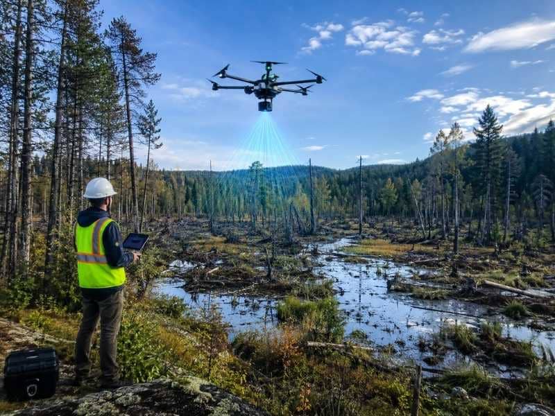
Surveying wet, wooded, or swampy land is tough. Surveyors can’t walk through thick brush or measure accurately across water. LiDAR technology changes this. Drones carry LiDAR sensors over difficult terrain and collect precise elevation data without setting foot on the property. This technology is reshaping how surveyors map hard-to-reach sites and plan construction on challenging land.
How LiDAR Helps Measure Hard Land
LiDAR stands for Light Detection and Ranging. It uses laser pulses that bounce off the ground and return to a sensor. By measuring how long the laser takes to bounce back, the system calculates the exact height of every point it hits. Millions of these measurements create a detailed 3D map of the land’s shape and elevation.
LiDAR works through obstacles that would stop traditional survey methods. It can measure ground elevation even under thick trees. The laser pulses penetrate dense vegetation and reach the soil below. Water doesn’t stop LiDAR either. The laser bounces off water surfaces and can help map shallow areas. This makes LiDAR ideal for swamps, marshes, and heavily wooded properties where surveyors can’t easily walk or set up equipment.
Traditional surveys require surveyors to navigate the land on foot, carrying heavy equipment and taking measurements at individual points. LiDAR collects data from above, covering large areas quickly. A drone can fly over a 500-acre property and collect elevation data in hours instead of days or weeks of field work.
Why Some Sites Are Hard to Reach
Many properties have natural features that make surveying difficult. Thick vegetation like mangroves, palmettos, and dense undergrowth block access and visibility. Soft, wet ground makes it impossible to walk safely or position equipment. Water features like marshes, swamps, and retention ponds become barriers. Uneven terrain with steep slopes and deep ravines adds physical challenges.
These conditions slow traditional surveys. Surveyors must find safe paths through difficult terrain. Equipment sinks into soft ground. Dense brush blocks sight lines needed for precise measurements. Weather creates additional delays. Heavy rain makes soft ground impassable. Wind affects visibility and measurement accuracy.
LiDAR bypasses these obstacles. A drone flies above vegetation and water. It doesn’t sink into soft ground. Bad weather is less limiting than for ground-based work. This makes LiDAR especially valuable in coastal regions and areas with significant water features or dense vegetation.
How Drones Help With LiDAR Mapping
Drones are the delivery system for modern LiDAR sensors. A small drone carries LiDAR equipment that weighs just a few kilograms. The drone flies a programmed pattern over the property, collecting data continuously. GPS tracking records the exact location of every measurement.
For construction projects, this LiDAR data shows where the land is high and low. It reveals slope directions and rates. It identifies low spots where water collects. This information helps engineers design roads, parking lots, building pads, and drainage systems. They can see the actual terrain before any design work starts.
LiDAR also helps with planning utilities. Engineers need to know ground elevations to design water lines, sewer systems, and storm drainage. LiDAR provides this data faster and more accurately than traditional methods. Drones can cover hundreds of acres in a single flight, collecting millions of elevation points.
What LiDAR Can Show Beyond Photos
Aerial photos show what the land looks like from above. They capture buildings, trees, roads, and other surface features. Photos are useful for seeing the general layout, but they don’t show ground elevation.
LiDAR reveals the shape of the land. It shows exactly how steep slopes are and which direction water flows. It identifies valleys and ridges. Under tree cover, LiDAR penetrates to the ground and shows the soil elevation. Photos can’t do this.
For construction planning, this elevation data is critical. A building pad needs to be level. Roads need proper slope for drainage. Parking lots need to shed water. LiDAR data tells engineers exactly what grading work is needed. Photos alone can’t provide this information.
LiDAR also detects small changes in elevation that photos miss. A two-foot depression that would collect water becomes visible in LiDAR data. A one-foot slope change that affects drainage shows up clearly. These details matter for construction planning and prevent costly mistakes.
When LiDAR Mapping Can Save Time
On large properties, LiDAR saves time compared to traditional surveying. A thousand-acre site might take weeks with ground crews walking every section. A drone flies over it in hours, collecting far more data points than any ground survey could capture.
LiDAR also reduces unsafe field work. Surveyors don’t have to wade through swamps or navigate through dense vegetation. They don’t risk getting lost in difficult terrain. Drone operators control the mission from a safe location.
For early planning stages, LiDAR data helps designers make better choices before expensive fieldwork begins. They see the actual terrain and adjust plans accordingly. This reduces the need for costly site visits and multiple surveys as the project evolves.
Frequently Asked Questions
What is LiDAR mapping?
LiDAR mapping uses laser technology to measure land elevation and shape. A sensor sends laser pulses toward the ground. By measuring how long the light takes to bounce back, the system calculates the height at each point. Millions of these measurements create a detailed 3D map of the terrain.
Why is LiDAR mapping useful for difficult sites?
LiDAR works through obstacles like dense vegetation and over water without requiring surveyors to walk the property. It’s ideal for swamps, wooded areas, and sites with challenging terrain that would be slow or dangerous to survey on foot.
Can LiDAR mapping help construction planning?
Yes. LiDAR data shows slopes, low spots where water collects, drainage paths, and exact elevation changes across a property. This information helps engineers design buildings, roads, parking lots, and utilities that work correctly on the actual terrain.