
Cadastral Surveyor vs. Property Surveyor: Why the Difference Matters in Land Records
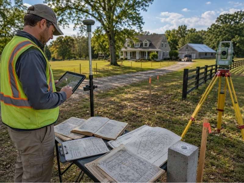
Many people think all surveyors do the same work. They don’t. A cadastral surveyor works with land records and legal documents. A property surveyor measures what’s actually on the land. Understanding the difference matters when you have questions about boundaries or ownership. Each type of surveyor brings different expertise.
What a Cadastral Surveyor Looks At
A cadastral surveyor focuses on land records and legal documentation. They study deeds, property descriptions, plat maps, and county records. They look at how property is registered in government systems. They trace the history of a parcel through ownership changes and lot splits.
Cadastral work is mostly office-based research. The surveyor reviews public records at the county courthouse or online databases. They piece together legal descriptions from deeds and assessor records. They check tax maps against recorded subdivision plats. They understand the legal framework that defines property ownership. When parcel lines are unclear in records, a cadastral surveyor investigates to find the answer.
This work is critical when ownership questions arise or when records conflict.
What a Property Surveyor Checks on the Land
A property surveyor goes to the land and observes what actually exists there. They measure property lines, mark corners with monuments, and record what they find. They check for buildings, fences, driveways, and other structures on the property. They note any improvements or encroachments. They verify whether what’s on the ground matches the legal description.
Property surveyors use equipment like total stations and GPS to take precise measurements. They photograph corners and mark them with stakes and flagging. They prepare drawings showing what’s actually there. Owners see where their property corners are located, where their boundaries run, and what improvements sit on the property.
The focus is physical reality, not records. If a fence is built three feet over the property line, a property surveyor finds it. If a corner monument is missing, they locate where it should be based on measurements and legal description.
Why Parcel Records May Not Match
Records in different government offices sometimes show different information about the same property. A deed describes a parcel one way. The tax map shows it differently. The county assessor’s records give different dimensions.
This happens for several reasons. Old deeds use descriptions that reference features that no longer exist. Tax maps get updated for different reasons than legal documents. Lot splits create new parcels, but old records don’t always get updated. Errors creep into old records and persist for years. Surveyor mistakes from decades ago remain in recorded documents.
A cadastral surveyor researches these conflicts. They trace each document back through time and find where discrepancies come from. Understanding why records don’t match helps clarify the true property boundaries. Sometimes one record is clearly correct. Sometimes the truth requires a property survey to establish the actual boundary.
How Lot Splits Can Change Records
When a property is divided into smaller pieces, new survey work must happen. The surveyor divides the parcel according to owner wishes and regulations. They measure the new boundaries and create a legal description for each piece. The split gets recorded as a new plat in county records.
For years after the split, both old and new records exist in the system. The original deed describes the large property. New plats describe the smaller pieces. If you research only one set of records, you get incomplete information. A cadastral surveyor pieces together the full history to show how the property evolved through splits.
Property records should be updated after every lot split, but offices sometimes lag. This creates confusion that cadastral surveyors are trained to untangle.
When Online Maps Are Not Enough
Google Maps and county online portals are convenient, but they’re not precise. Parcel maps shown online sometimes have errors. Boundaries shown on screen might be approximate or outdated. If there’s uncertainty about where your property ends or begins, online maps aren’t enough. If you’re involved in a boundary dispute, a survey is necessary.
A cadastral surveyor confirms what the legal records say about a property. A property surveyor confirms what actually exists on the ground. Together, they resolve confusion when records don’t match reality. Separately, either one can provide partial answers to simple questions.
For straightforward situations, online records plus a property surveyor might be enough. For complex histories, multiple owners, old lot splits, or conflicting records, both types of surveyor work together to clear up the confusion.
Frequently Asked Questions
What does a cadastral surveyor do?
A cadastral surveyor researches land records, deeds, plat maps, and public documents to understand property ownership and boundaries as they’re registered in government systems. They trace the legal history of a parcel and resolve conflicts between different records.
Is a cadastral surveyor the same as a property surveyor?
Not always. A cadastral surveyor studies records and documents. A property surveyor goes to the land and measures what’s actually there. One works in the courthouse. One works in the field. Both are trained surveyors, but their focus is different.
Why do parcel records sometimes not match?
Records don’t match because of old deeds using outdated descriptions, errors in old records, lot splits that weren’t fully updated everywhere, tax map changes that don’t align with legal records, or boundaries that have shifted over decades of ownership changes.
When do I need a cadastral surveyor vs. a property surveyor?
You might need a cadastral surveyor if you’re researching title, resolving record conflicts, or understanding complex ownership history. You need a property surveyor if you want to know where your boundaries actually are on the ground and mark them physically.
Can cadastral and property surveyors work together?
Yes. When records and reality don’t match, both types of surveyor work together to resolve the issue. The cadastral surveyor confirms what the records say. The property surveyor confirms what the land shows. Together they can settle disputes or clear up confusion.