
Why Land Surveys Are Critical in Flood-Prone Areas
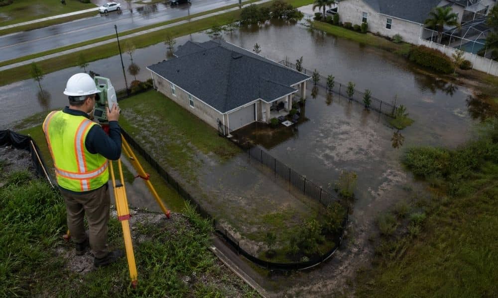
Flooding does not happen by chance. Water follows the shape of the land. If the ground slopes toward your home, water will follow that path every time it rains hard. That is why land surveys matter so much in flood-prone areas. They show what your eyes cannot see at first glance.
A property can look flat and safe. However, a small drop in elevation can send water straight toward a house. That small detail often goes unnoticed until flooding happens. By then, the damage is already done.
Flood Risk Starts With Elevation
The height of your land controls how water moves. Even a few inches can change the direction of flow. Some parts of a property may sit higher, while others collect water without warning.
Land surveys measure these differences with accuracy. They map slopes, low areas, and natural drainage paths. As a result, you can see how water will behave before a storm even hits.
Without this information, decisions rely on guesswork. That is where problems begin.
Why Maps Alone Are Not Enough
Many property owners check flood maps and feel confident. These maps, often provided by the Federal Emergency Management Agency, give a general idea of flood zones. They help, but they do not tell the full story.
Flood maps cover large areas. They do not show the exact shape of your lot. Two homes on the same street can have very different risks. One may sit slightly higher. The other may sit in a low pocket where water collects.
Land surveys fill that gap. They provide exact measurements tied to your property, not just the neighborhood.
Buying Property Without a Survey Can Backfire
Many buyers skip a survey to save money or speed up the process. That decision often leads to regret.
A property may look dry during a visit. Then a heavy storm hits, and water pools in areas no one expected. In some cases, the land may sit lower than nearby properties, causing runoff to flow toward it.
Land surveys help buyers understand these risks before closing. They reveal hidden issues that do not show up in listings or photos.
Flood Insurance Depends on Accurate Data
Flood insurance rates depend on elevation. The lower a structure sits compared to expected flood levels, the higher the cost.
An elevation certificate, based on land surveys, provides this information. If the data shows your home sits higher than expected, your insurance cost may drop. On the other hand, if it sits lower, you will know what to expect before you commit.
Without accurate measurements, you may end up paying more than necessary for years.
Construction Decisions Affect Water Flow
Building changes the land. Even small projects can shift how water moves across a property.
A new driveway, for example, can block natural drainage. Filling a low area can push water into a different direction. These changes may seem minor at first, but they can create serious problems over time.
Land surveys guide these decisions. They show how to place structures and shape the land so water flows away from the home, not toward it.
Small Changes Can Lead to Big Problems
Flooding does not always come from large storms. Sometimes, it starts with simple changes to the land.
Clearing trees, adding soil, or installing a fence can all affect drainage. Without a clear view of the land, these changes happen without planning.
Water then finds a new path, often into areas where it should not go.
With land surveys, property owners can see how each change affects the overall flow of water. That awareness prevents issues before they start.
Flood-Prone Areas Have Unique Challenges
Some locations face higher risks than others. Coastal regions, for example, deal with heavy rain, rising water levels, and shifting soil conditions.
These factors make it harder to predict how land will behave over time. A property that seems safe today may face new risks in the future.
Land surveys provide a detailed view of current conditions. They help property owners understand how their land responds to these challenges.
Permits and Approvals Often Require Surveys
Local agencies want to reduce flood damage. Because of that, they often require proof of elevation and drainage planning before approving construction.
Land surveys provide the data needed for these approvals. Without them, projects can face delays or even rejection.
Getting a survey early keeps things moving and avoids last-minute surprises.
Property Value Is Tied to Flood Risk
Flood risk affects how buyers view a property. It also affects how lenders and insurers assess it.
If a property has unclear conditions, buyers may hesitate. Sales can take longer, and prices may drop.
A clear survey removes that uncertainty. It shows exactly where the property stands and what risks exist. That transparency builds trust during a sale.
Land Surveys Help You Stay Ahead of the Problem
Flooding often feels sudden, but the signs exist long before the water rises. The shape of the land tells the story.
Land surveys reveal that story in detail. They show where water will go, how the land will react, and what risks may come next.
Skipping this step leaves too much to chance. Taking it early gives you control, clarity, and a better chance to protect your property from costly damage.