
When a Topographic Survey Changes the Pool Design
A pool looks simple on paper. Pick a spot in the backyard, draw the shape, start building. But once a topographic survey maps the actual land, that plan often needs to change.
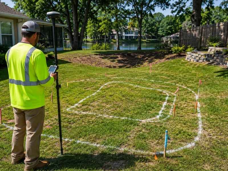
A topographic survey shows the real shape of a property. It finds high spots, low spots, and the way water moves across the yard. For pool projects, that information can change everything from where the pool sits to how the deck gets built. Skipping it at the start is one of the most common reasons pool projects run into problems mid-construction.
How a Topographic Survey Shows High and Low Areas
A topographic survey measures elevation at many points across a property and maps those measurements into a detailed picture of the land. It shows which areas sit higher than others, where the ground drops off, and where low spots collect water.
For pool planning, this matters right away. A yard that looks flat from the back door may actually have a slope of several inches across it. Some areas may sit low enough that water pools there after rain. Others may have a slight rise that affects how the pool deck connects to the surrounding ground. The survey shows all of this before any digging starts.
Why Drainage Problems Can Change Pool Plans
After a heavy rain, water has to go somewhere. On many residential lots, it flows toward a low corner of the yard or collects in a shallow depression. If the planned pool location sits in that same spot, the project runs into trouble.
A pool placed in a low area can create long-term drainage problems around the deck and equipment pad. Water that once drained slowly through the yard now has nowhere to go. Builders may need to move the pool to a higher area of the lot, adjust the grading around it, or add drainage structures to redirect water flow. The topographic survey finds these low spots early, before the pool layout gets locked in.
What Yard Features Can Affect a Pool Design
The ground itself isn’t the only thing that matters. Slopes near large trees can complicate excavation and root management. A gradual grade toward a fence line might limit where the deck can extend. Raised planting beds or retaining walls on one side of the yard can affect how the pool fits into the overall space.
A topographic survey records all of these features and shows how they interact with the land around them. That gives pool designers a complete picture of what they’re working with, not just the open space, but everything that borders or crosses it. Plans that look workable on a simple sketch sometimes don’t hold up once the full site picture comes into view.
How Uneven Ground Can Lead to Design Changes
Even a small change in ground height across a backyard can affect how a pool deck gets built. If one side of the pool sits eight inches lower than the other, the deck needs to account for that. Footings may need to go deeper. Steps may need to be added or removed. The finished grade around the pool has to slope away from the water in all directions to prevent runoff from draining back in.
When builders find out about these grade changes after construction starts, fixes get expensive fast. Concrete work may need to be torn out and redone. The pool shell itself may need to be repositioned. A topographic survey prevents this by giving builders the ground truth before any of that work begins.
Why Getting a Topographic Survey Early Can Save Time on Pool Projects
Pool design involves several rounds of decisions. The layout gets drawn, permits get submitted, and materials get ordered. Each step builds on the last. When a survey gets done after the design is already finished, problems found in the survey require going back to the beginning of that process.
A grade issue discovered after permits are submitted means revising the drawings, resubmitting for approval, and waiting again. A drainage problem found after excavation starts means stopping work and bringing in additional contractors. Both situations cost time and money that could have been avoided.
Getting the topographic survey done before the design is finalized keeps all of that from happening. The design can account for real site conditions from the start, and the permit drawings reflect what will actually be built.
Frequently Asked Questions
What is a topographic survey?
A topographic survey maps the shape of the land by measuring elevation at many points across a property. It shows high and low areas, slopes, and surface features that affect construction planning.
Why do I need a topographic survey before building a pool?
The survey shows the real conditions of the yard before any design gets finalized. Builders use that information to place the pool where it fits best and to avoid drainage and grading problems.
Can low areas in my yard change the pool design?
Yes. Low spots that collect water after rain can make certain locations unsuitable for a pool. The survey identifies those areas so the layout can be adjusted before construction starts.
What does a topographic survey show?
It shows slopes, high and low points, and surface features across the property. For pool projects, this includes any grade changes that affect the deck, the equipment pad, and drainage around the pool.
When should I get a topographic survey for a pool project?
Before the pool design is finished. Having survey data during the design phase means the plans reflect actual site conditions, which avoids revisions after permits are submitted or construction begins.